|
Eastern Region of India is home to some of the most underdeveloped region of India, especially states like Bihar, Odisha , Jharkhand and Chhatishgarh form the bottom most state on most economic parameters. Paradoxically, this is the case when these states are having the best economic potential of all the states in India.
Similar is the economic predicament of Nepal, a buffer country of immense strategic importance for geo-political stability of India and China, bordering Bihar.
However a new thought is dawning upon the federal policy makers of India which has now brought these states in renewed economic lime light. To give boost to mineral bearing states India has already done away with “Freight Equalization Policy” enacted in year 1954. New National Mineral Policy provides better safeguards for mineral bearing states. This is already reflected in large-scale investment commitment in states like Odisha, Chhatishgarh and Jharkhand. New development strategy of the region should be aimed at giving location advantage for industry in these three states which are source to more than 80% of India’s mineral resources. Also taking advantage of the vast coastline of Odisha has now a number of ports are planned to kick start port linked economic activity. Setting up of Paradip port and other deep water ports like Dhamra has now provided for an alternative Port access to this entire region, as against their sole reliance on Haldiya (Kolkata) port in the past.
Development plan for Bihar and Eastern UP is putting huge reliance on the revival of agriculture sector apart from rapid Urbanization. Attempt is also being made to harness the immense tourism potential of the region centering primarily on Buddhist circuit.
Nepal, on the other hand always been heavily dependent on its tourism potential and now efforts are being made to make it a hydropower hub as well. It has over 88000 MW of proven hydropower potential of which 42000 MW is considered to be economically viable. Exploitation of Hydropower will not only benefit the Nepal economy but will also get world rid of some of its global warming worries.
These development plans are, however, constrained by lack of supporting infrastructure. In fact, it is sought as one of the biggest reason for unrealized tourism potential of Buddhist circuit. Similarly, exploitation of Hydropower potential by Nepal is dependent on a good infrastructure for evacuating the huge amount of hydropower. New industrial townships planned in Jharkhand, North Odisha would also require good intra-city connectivity as well as connectivity to ports. This is also required for facilitating export and import of mineral resources. All these emerging cities will need to be on Gas Pipe Line grid and should have good communication network, establishing connectivity to population center of Bihar and Eastern UP in the hinterland and to outer world also.
Thus, to summarize, the future developmental strategy of this region is heavily dependent on:
-
Exploitation of abundant hydropower/ thermal power resources available in this region
-
Exploitation of abundant mineral resources, mineral processing and metal industry including export-import in mineral resources
-
Harnessing of immense international tourism potential of the region
-
Optimization of agriculture productivity, market linkages and development of agro /food processing industry.
-
Growth of international trade and commerce with Nepal, China and Asia Pacific.
-
Faster urbanization of the entire region led by secondary & tertiary sector to unburden the predominately agrarian economy in Bihar & Eastern UP.
-
Growth of silk industry, handicrafts industry, gems and jewelry industry, to feed on tourism boom.
Suggested project aims at providing world-class Infrastructure and connectivity to the major economic centers of this region and link them up with deep ports in most efficient fashion.
-
This project will touch upon life of over 300 million people in states like Bihar, Eastern UP, Nepal, Jharkhand, Chhattisgarh, Odisha and to a lesser extent the people in Eastern MP, North Eastern Region and even Tibet in future. This will open up the entire region to the world.
-
This Project will effectively have over 75% of India’s mineral resources in its feeder zone including almost 80% of Coal and over 60% of iron ore resources. Such a corridor will help movement of these minerals efficient.
-
Most of the metal producing centers and many of the thermal power plants, cement plants will be effectively supported by the infrastructure created in the corridor and will expand faster.
-
It will help develop linkages with Chinese economy overtime, which is, de facto, emerging as the new economic superpower. Such linkage between Indian & Chinese economy, with their likely emergence as the two largest economies, will have beneficial impact on the economy of the entire region.
Conceptual Structure of Project:
To address the above development needs and to achieve the state objectives setting up of an Economic Corridor is proposed. This economic corridor to be called “The Eastern Economic Corridor of India” will originate From Paradip port in Odisha and move through Jharkhand and Bihar to terminate at Katmandu in Nepal. Existing Road and Rail Roads will act as spur to provide for a much larger feeder area comprising of Bihar, Jharkhand, North Odisha, Eastern UP, Chhattisgarh, Eastern MP and North East.
The route of this proposed economic corridor will follow an almost North South alignment all through with spurs connecting to it in a fishbone configuration. However, spur links will be not part of the proposed project as most of these are already underdevelopment under various program of central government.
Specific components of the proposed economic corridor would be:
- 6/8 lane access controlled expressway
- Double/Three track High Speed High Capacity Rail Line.
- Multimodal logistic part along the route.
- A Gas Grid along the route.
- 770 KV Power Transmission Line with grid stations near all important township along the route
- Communication Line comprising of high bandwidth wireless and optical fiber network
- Sufficient water resources water reservoirs along the way for Industrial & Human Uses requirement
- Earmarking of six to nine locations along the way comprising of around 100 square KM area for supporting new Industrial townships.
- International Airport at Raxaul, Biharsharief, Hazaribagh, Ranchi, Rourkela, Katak
- Inland Waterways Port on Ganga at Bakhatiyarpur
Multimodal Logistic Nodes: at Chaudhawar, Rourkela, Ranchi, Barhi, Bakhatiyarpur Raxaul
Route Map of this alignment of proposed economic corridor is likely to be approximately 1100 KMs.
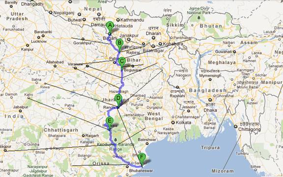
Note: Thick blue line indicates the corridor route map. Feeder corridors are highlighted in thin black lines.
Suggested Location for New Townships:
-
Raxaul/Motihari
-
Patori/Bakhtiyarpur
-
Rajauli
-
Barhi
-
Ramgarh/Ormanjhi
-
Basia/Konbira
-
Rajmunda
-
Pal Laharha
-
Chaudhawar
Rational for Proposed Route Map for “Eastern Economic Corridor”:
http://ibnlive.in.com/news/choudwarrourkela-industrial-corridor-begins/203827-60-117.html
http://www.orissalinks.com/orissagrowth/archives/5403
- It is aligned to Raxaul-Pardip via Bakhtiyarpur “Eastern Economic Corridor Proposed by Bihar Government
http://articles.timesofindia.indiatimes.com/2011-05-31/patna/29603967_1_central-schemes-bihar-power-plants
http://news.outlookindia.com/item.aspx?723593
- Same has also been recommended by PM’s “Task Force on Bihar” set up under planning commission.
http://planningcommission.nic.in/aboutus/taskforce/tsk_brs.pdf (page 4 point 9, page 19 point 29)
- It is aligned to North South Fast Track Corridor proposed by Nepal in six lane expressway configuration
http://www.adb.org/Documents/TARs/NEP/40011-NEP-TAR.pdf
- Ranchi-Barhi Kodarama Portion aligned with Jharkhand governments proposal for Industrial corridor way back in 2002
http://jharkhandindustry.gov.in/Jharkhand Industrial Policy 2011.doc
(14. INDUSTRIAL CORRIDOR, page 28)
http://www.telegraphindia.com/1110529/jsp/orissa/story_14042710.jsp
- Aligned with Nepals demand for Access to Vizag Port
http://www.business-standard.com/india/news/nepal-keenusing-vizag-port/373895/
http://www.nepalmonitor.com/2011/10/text_of_joint_press_.html (para 7)
- It is aligned to Asian Highway 42
http://www.unescap.org/ttdw/common/TIS/AH/maps/ah_map_latest.jpg
- Muzaffarpur- Rourkela Stretch is already identified for “National Express Way Plan”
http://morth.nic.in/writereaddata/linkimages/SL_Final_Report_Part13901147970.pdf (Page 86)
- It is also aligned along Trans Asian Rail Route from Bihar to Nepal via Raxaul which may extend to China in time to come.
http://www.unescap.org/ttdw/common/TIS/TAR/images/tarmap_latest.jpg
- China has plan to link up Kathmandu with its Rail network
http://www.nepalnews.com/archive/2011/others/guestcolumn/jan/guest_columns_06.php
http://www.economist.com/node/17204635
http://nitdb.org/about_nitdb.html
- Raxaul is an integrated check post of under Land Port Authority of India
http://mha.nic.in/pdfs/BM_IntCheck%28E%29.pdf
- Subsumes two important international tourist circuits, that is, Gaya, Rajgir, Nalanda, Vaishali, Keshariya portion of Buddhist circuit and Bhuvaneshwar- Puri- Konarka-Chilka circuit apart from destinations like Kathmandu, Mount Everest, Pokhara which are quite popular with international tourists.
http://www.mapsofindia.com/maps/india/tourist-circuits.htm
- Part of Gail’s Jagadishpur-Gaya-Haldiya pipe line crisscrosses this corridor and can be suitably extended alongside. Also, Gail is setting up FRSU at Dhamra
http://www.iploca.org/platform/content/element/10491/GAIL-Mr.A.Prasad.pdf
http://www.dnaindia.com/money/report_gail-jilts-bengal-goes-to-dhamra-for-floating-unit_1612093
- Route has large number of rivers, water reservoirs and other water bodies along the route to support emergence of new Townships.
- Reservoir on Brahmani River
- Reservoir on Sankh River
- Reservoir on South Koel River
- Reservoir on Suwarnrekha River
- Reservoirs on Barakar River
- Reservoirs on Damodar River
- Reservoir on Sakri River
- Ganga River
- Budhi Gandak
- Reservoir on Gandak
- Baghmati
Project Timeline Window:
Development of such a corridor has assumed an added urgency as already similar kind of disjoint effort is underway at level of states involved to support their emerging economic needs. The new township built around mega steel plants being set up by likes of Arcelor Mittal, Posco, Tisco, Jindal Steel will also be coming up in the next few year times. Then, there are several large industrial projects in offing like thermal power plants, cement plants and aluminum smeltering units along with numerous mining and mineral processing units. These are coming up all along the route of proposed Industrial corridor, putting huge demand on the existing infrastructure. With a proper industrial corridor, industrialization of the region will get a big fillip. Also, industry will find it easy to decide upon locations minimizing possibility of haphazard growth having big implication for environment.
Similarly, Bihar Governments has big plans around Buddhist Circuit and also in regards to Nalanda International University. Process has already been put in motion. Number of international tourist in state has jumped from sixty five thousand odd in 2005-06 to above half a million mark now. Failure to improve the infrastructure will put a severe strain on capacity to handle tourist influx and effort to promote it further. On the other hand, linking Chilka-Puri-Konark circuit to Buddhist Circuit of Sarnath-Bodhgaya-Nalanda-Vaishali-Keshariya- Kushingar- Lumbini-Shrawasti and then to Kathmandu-Pokhara-Mount Everest Circuit, will give a big impetus to international tourist inflows in the entire region. It will also help overcome the problems bedeviling the Nalanda International University project, or even the problems associated with setting up of central university at Motihari.
Nepal has also started awarding several of their medium sized hydropower projects now. These will require development and strengthening of power transmission lines for evacuating its generated hydropower. Further, this corridor will help resolve Nepal’s persistent grudge against India on accessibility to ports. This is very important strategic requirement as delaying this will push Nepal in waiting hands of China which will make our peaceful northern border problematic. It is in India’s geostrategic interest to counteract adverse influence of China in Nepal by treating needs of Nepal on priority
Stakeholders Involvement & Stated Needs:
Various stakeholders have already been making disjoint efforts at developing the required connectivity. For example Nepal has always been demanding a faster Port Access for itself through Bihar. Bihar government has already been asking for this corridor and the same has been supported by Jharkhand. These state governments are already pushing for an expressway and high speed rail corridor from Jamshedpur to Ranchi to Patna along the same alignment. Odisha government has also already going ahead with linking Paradweep Port to Kendujhar Private entities like Tata group are also developing smaller ports like Dhamara along the same alignment.
Proposed Executing Agency and Involvement of Private Sector:
Government of India has got appropriate executing agency like NHAI, Rail Vikash Nigam, BSNL, Container Corporation of India, Powergrid Corporation, NHPC and also GAIL which are quite experienced in executing various components associate with such an economic corridor.
These proposed executing agencies do have all the necessary capability to execute these projects in PPP mode as well. In fact, Dhamra Port is being developed by Tata’s through a joint venture. Since large numbers of private industries are going to be based along the route and there is paucity of good infrastructure in the region, this project will definitely evoke good response from private sector stakeholders as well.
Approximate Project Cost:
Estimate cost for six lane expressway and double track rail line taking into account the existing infrastructure would be in the range of INR 60,000 crores, Break Up:
-
Double Tracking of the Rail Route: INR 10,000 crores
-
Expressway Cost: INR 40,000 crores
-
Gas Grid: Private Investment
-
Broadband Network: Private Investment
-
Power Grid Network: Private Investment
-
Water Reservoir: Existing Plans Suffice
-
Land Acquisition & Township Development Cost: Self Financing (pvt)
-
Logistic Park: Private Investment
-
International Airport: PPP Mode
-
Inland Ports & PPP Support Fund : INR 10,000 crores
Initial funding can be arranged from World Bank & ADB and Banks.
Project Period: Four Year
- Creation of sinking fund with state contribution of Rs. 3000 crores per year (approximately @ 1000 crores by each of three state governments)
- Federal investment commitment of Rs. 5000 crores per year
Total equity of governments over four years 32,000 crores
- ADB & World Bank funding ($ 2 Billion) 10,000 crores
- Other domestic borrowings: 18,000 crores public borrowing.
Economic return can then be worked out in terms of traffic potentials, charges on international tourists and domestic tourists and so on.
Techno-economic Feasibility & Social Impact
Technical feasibility of corridor is evident in the existing status itself. Entire route is already being put on a 4-lane Highway and at least a single track railway line along its entire length along with supporting ports. Only a small portion requires either an alignment change or plugging of missing links. Length of the missing links /alignment changes is likely to be less than 20 Km in case of Highways and around 80 Km in case of railway lines. Industrial townships are already springing up all along the route, irrespective of whether this corridor is planned to streamline the same or not.
Social impact of the same is likely to be quite beneficial for the region as well as the country. Entire region is largely underdeveloped more so because of poor connectivity in the recent time. Traditionally, this region has been nerve center of all economic, political, social and civilization activities with Pataliputra (Patna) as capital of ancient Pan South Asian Empire.
Other advantages of this project are as follows:
- Will help establishes a Rail & Road Based Trade Route Between China & India
- Most Efficient Rail & Road Based Port Access to Nepal & also Tibet.
- Faster and Alternative Port Connection for the entire Dependent feeder Regions of Eastern UP, Bihar, Northern Chhatishgarh, Eastern MP, Jharkhand and Northern Odisha .
- Opens up the most efficient mineral & metal Export & Import route for India.
- Will give rise to a Mega Tourism Circuit Improving Connectivity to Buddhist circuit as well.
- Provides connectivity to new Mega Industrial Townships.
- Ensure better inter-connectivity for existing Industrial & commercial cities in the eastern region.
Prima Facie, this project appears not only economically feasible but quite attractive as well. This is likely to have a very short payback period, though the exact assessment of the same need to be done.
Continuing with same arrangement of state and central contribution for subsequent seven years, loan amount can be paid back in around seven years.
As such, this could be easily one of the most attractive and high return economic corridor projects anywhere in India, and certainly the one which can be planned for eastern region of India. Also, this is one project which will touch the life of the largest populous in these under-developed regions of India. This will herald a slew of new economic activity in the entire development deficient eastern region.
comments...
| 
