|
06/05/2013
Bihar at the
Confluence of International Economic Corridors
Prateek K Anand |

In pure economic terms, Bihar is very much geo strategically located as would be soon realized. Its olden glory wan not a fluke. It has all the necessary ingredients to become an international economic hub once again. Just that it requires a visionary who can help realize its immense potential. Being located at the national, or rather international, cross roads has a tremendous advantage. Earliest this potential is recognized, the better would be the outcome for the state. Three potential international economic corridors, as identified in the study of various multilateral agencies, are set to converge at this “Sangam” (confluence) of Economic Corridors, that is, Patna. These emerging corridors are: 1. “Eastern Economic Corridor“ (Raxaul- Patna- Rajauli- Ranchi- Rourkela- Chaudhawar(Katak) –Paradip)- along Larger China- Nepal and India Neo Silk Route 2. “Amritsar Delhi Kolkata Industrial Corridor” – (Amritsar- Ambala- Roorkee-Delhi- Luknow- Patna- Hazribagh-Kolkata)- Along West Asia South Asia Trade Route 3. “North East Frontier Economic Corridor” – ( Patna – Siligudi – Guwahati- Aizawl) – Along Mekong Ganga South Asia South East Asia Economic Corridor Studies sponsored by UNESCAP and ADB have invariably ended up advocating the aforementioned economic corridors with a small variations here and there. Also, various stakeholders have voiced their desire for such a corridor on a number of occasions. Sangam of Economic Corridors: United Nation’s Economic and Social Commission for Asia and the Pacific (UNESCAP) has been working on various s regional and sub regional integration program. It has been spearheading an effort on Asian Integration and has come up with a set of Roadways Identified as Asian Highways (figure 2) and also a Trans Asian Railway Network (figure 3). Two Main Asian Highways namely Asain Highway 1 originating from Japan and ending up at Turkey would be passing along the Grand Trunk Road in Bihar. Another Asian Highway System originating from Indonesia is set to pass through Tarai Region of Nepal. Yet another highway that is Asian Highway 42 will connect mainland china to Dobhi near Bodhgaya in Bihar. As for railway network, main trunk of Trans Asian Railway will pass along Grand Chord ( parallel to GT road), but it will split up to cover Main Line Passing through Patna and another split up at Mokama to link up Raxaul and thereafter Tarai Region. Red lines in the figure 1 depict Asian Highway system and other colour lines depict the Trans Asian Railway network.Different colour has been used for depicting different rail gauges. Blue circles indicate existing dryports and white ones are the proposed dryports.
: Composite Map of Asian Highways, Railways and Dryports (Source UNESCAP)
: Asian Highways System (Source UNESCAP)
Figure 3 : Trans Asian Railways (Source UNESCAP) 1. Eastern Economic Corridor”- Studies sponsored by both ADB and UNESCAP has strongly advocated development of the underlying corridor with some variations. There has been explicit advocacy for developing this route by government of China, Nepal and India under their respective jurisdictions. Besides, government of Bihar, Jharkhand and Odisha have been raising demand for this “Economic/ Industrial Corridor” in the various forums. These states have demanded development of this corridor through their planning and industrial policy documents as well. Even the planning commission task force on Bihar has strongly recommended setting up of “Eastern Economic Corridor”. Suggested route map for this corridor is Raxaul- Rajauli- Ramgarh- Ranchi- Rourkela- Chaudhawar- Paradip as in figure 4. However, some of these documents of Bihar and Jharkhand government have been proposing an alternate route through Ranchi- Jamshedpur- Baharagora or Ranchi – Chaibasa- Kendujhar –Jajpur. Alignment with Odisha government’s proposal, interest of Chhatishgarh state and also greater socio- economic need of naxal affected areas would require an alignment along the suggested route. A spur route through Ranchi- Jamshedpur- Bahragora and Haldiya / Dhamara besides the aforementioned trunk route would be an ideal alignment. Route map of corridor proposed by ADB is given in figure 5.
Figure 4 : Suggested Trunk Route of Eastern Economic Corridor (source Bihar Times)
Figure 5 : Kathmandu-Haldiya Corridor (ADB Study on South Asia sub Regional Cooperation)
2. Amritsar Delhi Kolkata Industrial Corridor- Study by UNESCAP has strongly advocated Istanbul-Tehran-Lahore-Delhi-Kolkata-Dhaka-Rangoon trade corridor. Same has been underscored by the ancient surface trade routes. Government of India has recognized the importance of this corridor now. Prime minister has recently announced formation of an Inter Ministerial Group to formulate outline of this industrial corridor. Proposed route map of this corridor is given in figure 6. Demand for this corridor has been invariably raised by Punjab, Uttar Pradesh, Bihar and West Bengal in a number of forums, including during planning commission consultations and in course of parliamentary discussions. Route map proposed in a study sponsored by UNESCAP is shown in the figure 6. South Asian portion of railway route of this corridor is indicated in blue lines. (
Figure 6 : Proposed Trunk Route of Amritsar Delhi Kolkata Industrial Corridor (Prime Minister of India Tweets)
Figure 7 : Istanbul- Tehran- Lahore- Delhi- Dhaka Trade Route (UNESCAP)
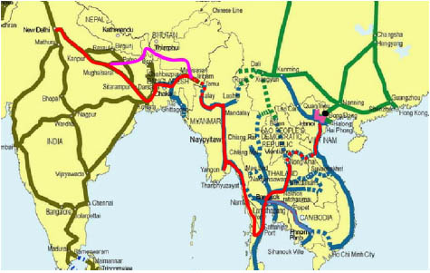
3. “North Eastern Frontier Economic Corridor” - Prime mover for Mekong Ganga economic corridor is Asian Development Bank. A strong stakeholder in this corridor is the government of Assam. There has been a demand for such a corridor from other north eastern states as well. Indian government railway consulting and engineering firm ‘Rites’ has also proposed a rail route along the way to connect to South East Asia as in shown by pink line in figure 8. Chief Minister of Assam has during a recent National Development Council meeting demanded a trunk route of National Gas Grid along this route. During regional consultation with planning commission also there has been a demand for an industrial corridor albeit along a different alignment. There has been a demand for ‘Seven Sister’s Industrial Corridor’ from many quarters as well. Government of India has already been working on Sittwe- Kaladan- Aizawl- Guwahati leg of the multimodal transportation corridor as depicted in figure 9.
Figure 8 : Suggested Rail Map for South East Asia (RITES)
Figure 9 : Sittwe Aizawl Multimodal Transport Corridor Proposed link up with GMS region corridors: Asian Development Bank has been strongly advocating sub regional and regional integration. It has been involved in developing corridors in Greater Mekong Region. These economic corridors spread across South China, Laos, Kambodia, Thailand and Myanmar has been shown in figure 10 below. Studies sponsored by ADB have been advocating need for developing an Economic corridor extending from South East Asia to South Asia. This proposed corridor has been alternatively called as Mekong Ganga economic corridor. Figure 11 outlines the proposed transport corridors to link up with North Eastern Provinces of India. There on the same is proposed to extend to Indian Heartland of Ganga valley. Approach advocated for development of this corridor entails the following four steps: 1. Development of Transportation Corridor as the Main Trunk Route of the Proposed Corridors a. Highway Corridors b. Railway Corridors c. Inland Waterways Network d. Shipping Corridors / Ferry Services e. Civil Aviation Connectivity f. Energy/ Gas Grids 2. Development of a Trade Corridor a. Dry Ports b. Trade Facilitation Centres c. Transhipment Points d. Trading Hubs 3. Development of Cities and Urban Infrastructure a. Industrial Cities 4. Full-fledged Development of Economic Corridor a. Economic Hubs b. Industrial zones
Figure 10 : Proposed Corridors in Greater Mekong Sub Region (GMS) (source ADB)
Figure 11 : Proposed Mekong- Ganga Link Up (source ADB)
Emerging geo-economic realities demand a nimble footed response from the government of Bihar. It needs to seize upon these golden opportunities and lead the charge from the front. Leaving it in the hands of central government would not be good enough. From prodding the central government to doing it parts in infrastructure development for the said corridors, state can do a lot. At the moment, however, it is difficult to make out from the available information if the leadership in Bihar is aware about all of these developments. I have only seen some initiatives in regards to “Eastern Economic Corridor” till date, but nothing of this sort in regards to “North Eastern Frontier Provinces Economic Corridor”. I have also not seen any initiative or heard of a talk in regards to developing much exalted Mekong Ganga Corridor, notwithstanding the entire buzz around Nalanda International University.
|